
Mapping API
Our Mapping API offers the capability to conflate your internal or 3rd party road network to the Geo Location Platform road network. The Geo Location Platform can process data from any map or location data source, so interoperability is guaranteed. This enables you to decode the output of the Geo Location Platform APIs into your road network identifiers, which makes the API output usable for further processing inside your system. You can also map a set of geo-positions with headings to the most probable links (with offset) in the Geo Location Platform's road network. The Geo Location Platform's road network is sourced from Open Street Map. The returned road network link identifier is derived from the OSM identifier, however, is not the original OSM identifier. Once an OSM identifier changes, the road network link identifier changes as well.
Following endpoints can be used
- MapPoint - For mapping list of single points
- MapPolylines - For mapping poly-lines
You want to know what's new? See API changelog
Get started!
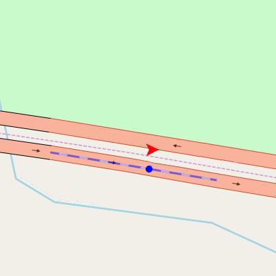
MapPoint
Mapping of list with single points.
HTTP method: POST
Endpoint requires authentication. API_KEY needs to be provided to you by Kapsch TrafficCom. Please contact us for API usage conditions and to acquire your API_KEY. Usage of 'demo' API_KEY in examples on this page is not allowed for your productive systems.
- URL parameter "includeShape" - Returns the geometry of the link if TRUE (default is FALSE)
Request example
Use HTTP POST method https://api.geo-location-platform.com/roadnetwork/europe/v1/mapPointand send below request body.
JSON request details:
- "mappingRadius" - Radius of how far around the point should be searched (in meters)
- "points" - Array of points
- "customId" - Custom ID (this will be returned in response)
- "point" - Consist of "lat" (latitude) and "lon" (longitude)
- "heading" - Heading of the point in degrees
- "maxAngle" - Maximum angle (optional)
- "linkClassHint" - Hint for link class (optional)
- "linkReferenceHint" - Hint for link reference (optional)
- "linkNameHint" - Hint for link name (optional)
Response example
JSON response details:
- "points" - Array of points
- "customId" - Yor custom ID that was specified in the request
- "mappedLinkId" - Id of the mapped link
- "mappedLinkOffset" - Offset from starting point of the link (0 to 1)
- "confidence" - Level of mapping confidence (0 to 1) - Currently always 0
- "mappedPoint" - Consist of "lat" (latitude) and "lon" (longitude) and represents a mapped point
- "shape" - Shape of the mapped link (returned only if "includeShape" parameter is set to TRUE)
- "type" - Always "LineString"
- "coordinates" - Array of "lat" (latitude) and "lon" (longitude) coordinates and represents a shape of the whole link
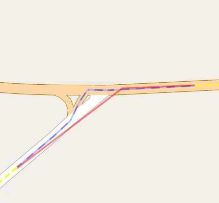
MapPolyline
Map list of polylines. Each polyline should contain at least two points.
HTTP method: POST
Endpoint requires authentication. API_KEY needs to be provided to you by Kapsch TrafficCom. Please contact us for API usage conditions and to acquire your API_KEY. Usage of 'demo' API_KEY in examples on this page is not allowed for your productive systems.
- URL parameter "includeShape" - Returns the geometry of the link if TRUE (default is FALSE)
Request example
Use HTTP POST method https://api.geo-location-platform.com/roadnetwork/europe/v1/mapPolylineand send below request body.
JSON request details:
- "snapToNodeDistance" - Distance when snaping to node (in meters)
- "minSearchRadius" - Minimal radius for searching (in meters)
- "polylines" - Array of polylines
- "customId" - Custom ID (this will be returned in response)
- "points" - Array of "lat" (latitude) and "lon" (longitude) coordinates that represent a polyline. (Minimal 2)
- "linkClassHint" - Hint for link class (optional)
- "linkReferenceHint" - Hint for link reference (optional)
- "linkNameHint" - Hint for link name (optional)
Response example
JSON response details:
- "polylines" - Array of polylines
- "confidence" - Level of confidence of mapping (0.00 to 1.00)
- "customId" - Custom ID that was specified in the request
- "startOffset" - Start offset on the first link (0 to 1)
- "endOffset" - End offset on the last link (0 to 1)
- "totalLength" - Total length (in meters)
- "warningCode" - Warning code that gives you hints about the confidence
- "links" - Array of links
- "id" - Unique id of link (if negative the link is reversed)
- "confidence" - Confidence of mapping for this link (0.00 to 1.00)
- "length" - Length of the link (in meters)
- "shape" - Shape of the mapped link (returned only if "includeShape" parameter is set to TRUE)
- "type" - Always "LineString"
- "coordinates" - Array of "lat" (latitude) and "lon" (longitude) coordinates and represents a shape of the whole link